
Cycling the Col du Parpaillon
The lost Alpine route in the Vallée de l'Ubaye
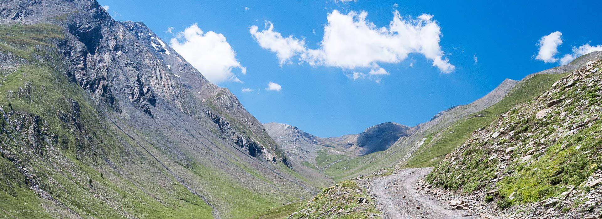
Head south from Briançon and you enter the Vallée de l’Ubaye over the famous 2109m Col de Vars, now a classic climb stage in the Tour de France. However, further along the mountain ridge lies an earlier, much higher pass created by the military: the Route du Parpaillon. Long since abandoned, the old trace (which includes a remote and mysterious tunnel) scaled the wild, rugged Massif du Parpaillon and still appears on larger-scale maps. Was it, I wondered, still possible to cycle over the col and the Route du Parpaillon from end to end? Attempting it on a mountain bike seemed like the ideal way to find out. The local tourism people, though, feel the time-frame is limited: “The problem is the tunnel; most of the year it’s frozen up with ice and snow. But after the middle of June it should be open… until the snows come again”.
Once a key route for military supplies, the Route du Parpaillon was abandoned in favour of the lower Col de Vars, which could be kept open in winter. Today, the old route is popular for walkers and cyclists and offers stunning mountain scenery.
We return to the Vallée de l’Ubaye
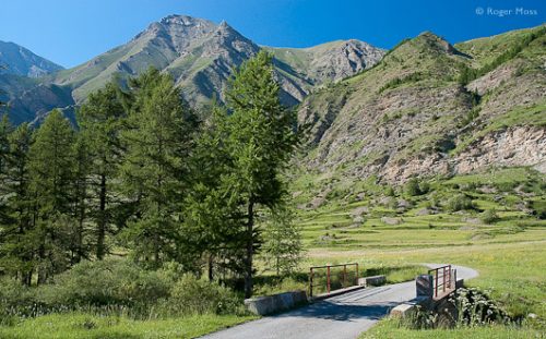
After months of increasingly lengthy training rides, I find myself back in Ubaye, renting a convincingly rugged full-suspension bike and feeling distinctly uneasy about what lies before (and above) me. The Route du Parpaillon originally served the Fort de Tournoux, a vast military complex defending the eastern end of the valley from above the village of La Condamine-Châtelard. From here a tarmac road climbs through a series of tough hairpin bends to over 1800m, passing the family ski station of Sainte-Anne. Not knowing what awaits, I decide to drive this gruelling but hardly undiscovered 6km section until the tarmac finally runs out beside the tiny Chapelle Sainte-Anne, where it’s time to transfer to two wheels.
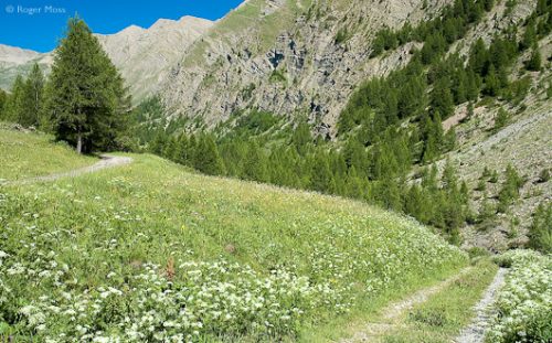
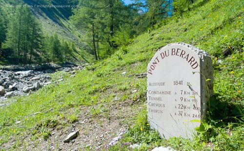
The old route begins as a gravel track among lush wildflower meadows, but soon enters dense, echoing forest and climbs steadily up the side of a deep, curving valley. A few minutes’ determined slog on the woodland track brings me to the Pont du Bérard, an idyllic spot where an inscribed stone beside a craggy cascade records, among other things, the altitude (currently 1841m) and distance to the tunnel: 9km 995m.
The Route du Parpaillon begins
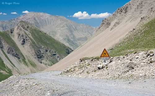
Progress now becomes slower and the pulse rate faster on a steep hairpin climb through the tree-cover, from which I finally emerge to confront a cheerful cabin equipped with a gently-humming generator. Unlike the small group of walkers following the GR 6 footpath, I resist the temptations of the Buvette Grill le Petit Clausis and instead press on over a rugged stone and timber bridge spanning the Ruisseau du Parpaillon, which must take a lot of spring meltwater but in summer is little more than a small stream. From here things really open out, the rough track ahead laid out like a dull grey ribbon following the contours of the steep valley sides past the grandly-named Cabane du Grand Parpaillon (2031m), the only obvious man-made feature. The colours of this now-remote landscape are almost surreal, with areas dull, bleached-out shale showing through grass struggling to thrive beneath the burning sun hanging in a deep blue sky.
The relentless, steady climb makes progress painfully slow, the combination of hot sun and high altitude compounding the effort required. The scenery, though, becomes ever more amazing, with few obvious clues as to the route’s former importance until I ride over a short section surfaced with intricately aligned stonework. It’s hard to imagine the whole Route having been constructed so painstakingly, or that this would be the only sections to have survived. For now it must remain a mystery.
No let-up
Higher still the track becomes more tortuous, finally tightening into a seemingly endless hairpin ascent, repeatedly crossing and re-crossing a deep gully gouged by torrents of rain and melt-water cascading down to the valley floor far below. Each is spanned by a timber bridge looking more structurally unsound than the last, with gaping holes exposed between sagging, time-worn timbers. There’s no way of knowing how old they are, but nothing has an easy life up here in these exposed conditions. Soon the track reaches a section of unstable rocky debris which have clearly slid down the mountainside and look set to continue.
At last, the tunnel appears…
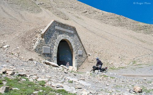
I press on, though, and eventually round what turns out to be the final bend of the climb. In the distance I recognise what must be the legendary Tunnel du Parpaillon, but looking pretty insignificant amid the vastness of the surrounding landscape. But the sight inspires a final burst of energy, acknowledged by a stirring round of applause from a large group of Italian long-distance hikers taking a picnic break. After the demands of the climb I dismount thankfully and begin to take in the incredible surroundings. On the stonework around the tunnel entrance are inscribed its constructors (le Génie, or military engineers) and the altitude: 2643m (almost 9,000ft). This almost cetrainly makes it Europe’s very highest road tunnel. The spot is both uplifting and yet desolate in its remoteness, with little greenery able to survive on the stark, visibly unstable terrain between the tunnel and the Col du Parpaillon looming high above it. Not surprisingly, keeping the Col open (and maintaining the Route’s viability) during winter proved impossible, so the tunnel was bored through the rock 60m or so below the ridge and opened in 1901.
No turning back
Peering beyond a pair of huge steel doors into the entrance, after years of semi-abandonment, is quite literally a chilling experience. A very few metres in, all is total darkness, and echoing around it all there’s an eerie sound of water dripping from between the rocks of the unfaced tunnel roof. In other words, it’s as every bit as unwelcoming as I’d been told to expect. But I’m determined not to turn back, so in the baking sunshine I put on a thermal fleece from my back-pack, along with what was described as a long-range LED head-light, then climb back on the bike. One deep breath later I select a low gear, brace myself and launch off into the tunnel at a steady pace, hoping to keep moving through the deep pools of water I can already see and to aid stability if and when I hit the expected sheet ice.
Chill-Factor
As predicted, the cold inside is chilling and the darkness soon becomes total, as the tunnel course was not bored straight, but actually curves throughout its 468m length. This makes it impossible to see the exit until you’re some way in. Eventually, though, a tiny white dot appears, and I focus upon it while trying to blocking out thoughts of what might be hanging in the darkness overhead. Before long I hit ice, too, but I manage to keep moving.
When I finally reach the warm sunshine again I have a real sense of elation and personal achievement. A young Italian cyclist and his girlfriend, looking doubtful, ask me if its safe to ride through, but decide against it when I mention the icy cold. For me, though, it’s all behind me, and I focus instead on the beauty of the very different landscapes which are now unfolding ahead.
It’s all downhill from here
From here it’s all downhill, on a stony, unsurfaced track which swirls its way between mountain pastures filled with Alpine wildflowers. Things are much softer on this side of the mountain, with none of the almost desolate sense of remote abandonment I’d seen on the long, arduous climb. This is picture-postcard mountain imagery, adding a whole new dimension to what has turned out to be, as I’d always suspected, an epic journey. Eventually, after crossing a fast-flowing stream and passing a few rugged stone cabins and timber crosses, I re-enter the tree-line, in the form of silent conifer forest sheltered by the surrounding mountains. Minutes later the gravel gives way unexpectedly to tarmac before a steep, rocky track forks off, signed to Crévoux. I continue down more sedately to cross the Torrent de Crévoux, emerging into a broad valley above the starkly authentic-looking hamlet of La Chalp.
The journey is almost complete, apart from a final streamside descent beside to the Vallée de la Durance. In the village of Crévoux is a time-worn painted plaque recording the completion in 1891 of a major section of the Route Militaire du Parpaillon by the 6th Group Alpin. Their great adventure made it possible to undertake mine. 

